Blog
02
Jul
Sylhet to Bichanakandi Distance
Sylhet to Bichanakandi Distance, Travel Time & Complete Route Guide
Bichanakandi is close enough to Sylhet city for a day trip, but the journey feels much farther once the city roads give way to green countryside, rocky riverbeds and hills along the Bangladesh-India border.
So, how far is Bichanakandi from Sylhet?
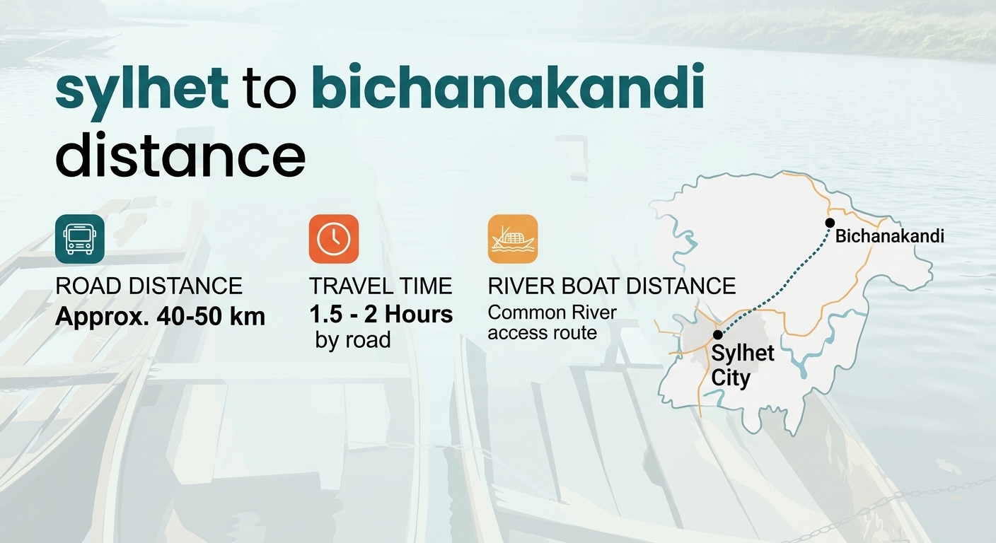
The Sylhet to Bichanakandi distance is roughly 30–40 km, depending on your starting point and route. A commonly cited road route is around 39 km, with a theoretical driving time of about an hour. In real travel conditions, however, you should allow around 1.5 to 2 hours because road conditions, traffic and the final approach can affect the journey.
This guide explains the distance, travel time, best ways to reach Bichanakandi, what the route is like and how to plan the trip without rushing.
Quick Answer: Sylhet to Bichanakandi Distance
The exact distance can vary because "Sylhet city" can mean different starting points, and travelers may approach Bichanakandi through different roads. A current route calculation lists the road distance at about 39 km, while Sylhet district tourism information gives approximately 30 km by one approach and notes an additional boat journey in that route.
For trip planning, 30–40 km is a more useful figure than treating the journey as exactly one fixed distance.
How Long Does It Take From Sylhet to Bichanakandi?
Under good road conditions, the journey can take around 1 to 1.5 hours by road. For a more realistic travel plan, allow 1.5 to 2 hours each way.
The difference comes down to traffic, weather, road conditions and where you start in Sylhet.
You may also need additional time for the final part of the journey, depending on the route and local transport arrangements. The official Sylhet district tourism information describes an approach where part of the journey is completed by road and the remaining stretch by boat.
That means you shouldn't plan your Bichanakandi visit around a tight timetable.
If you're leaving Sylhet city in the morning, an early start gives you more time at the destination and makes it easier to return before evening.
Route From Sylhet to Bichanakandi
The journey takes you northwest from Sylhet toward Gowainghat. Bichanakandi is located in Rustompur Union of Gowainghat Upazila and sits close to the Bangladesh-India border. The area is known for its Khasi hills, rocky landscape and streams flowing through the stones.
The route generally looks like this:
Sylhet city → Gowainghat area → Bichanakandi
The final section can feel quite different from the city. Instead of busy urban streets, you'll see villages, open fields, greenery and waterways.
This change in landscape is part of what makes the trip enjoyable.
For a wider look at the region's attractions and how Bichanakandi compares with other places around Sylhet, see our guide to the best tourist places in Sylhet.
How to Travel From Sylhet to Bichanakandi
You have several options for getting to Bichanakandi.
Private Car or Microbus
A private car is one of the easiest choices if you're traveling with family or a small group.
You don't have to follow a fixed public transport schedule, and you can leave early. A reserved vehicle also makes it easier to stop for food, photographs or short breaks along the way.
It's particularly useful if you want to visit more than one attraction around Gowainghat on the same day.
If you're considering private transport, our guide to renting a car in Sylhet covers the main considerations when arranging a vehicle.
CNG Auto-Rickshaw
CNGs can be a practical option for budget-conscious travelers.
You can look for local transport toward the Gowainghat and Bichanakandi side of Sylhet. Depending on your arrangement, you may need to change vehicles or arrange local transport for the final stretch.
For a first-time visitor, it's worth confirming the complete route and fare before starting the journey.
Reserved Transport
For families and groups, reserving a CNG, car or microbus can make the trip simpler.
The biggest advantage is flexibility. You can decide when to leave Sylhet, how long to stay and when to return.
For a day trip, that flexibility can be more valuable than saving a small amount on individual fares.
What Makes Bichanakandi Worth the Trip?
The distance is modest, but Bichanakandi feels distinctly different from Sylhet city.
The landscape is dominated by large stones, flowing water and layers of Khasi hills. The official Sylhet district tourism description highlights the streams flowing over the rocks and the hills meeting near the border.
During the rainy season, the water flow becomes stronger and the landscape becomes particularly dramatic. Clouds often hang around the hills, while water runs between the rocks.
In the drier months, more of the rocky riverbed becomes visible.
This gives Bichanakandi a different character depending on when you visit.
Best Time to Travel From Sylhet to Bichanakandi
Your choice of season can change the experience considerably.
Monsoon
The rainy season is one of the most visually striking times to visit.
More water moves through the rocky landscape, and the surrounding hills become lush. However, wet rocks can also become slippery, and water conditions may change quickly after heavy rain.
If you're visiting during the monsoon, don't treat the rocky riverbed like a normal walking trail.
Winter
Winter is generally more comfortable for road travel and outdoor sightseeing.
The weather is cooler, visibility can be better and walking around the rocky areas is usually easier than during heavy rain.
However, the dramatic water flow associated with the rainy season may be less pronounced.
For broader seasonal planning, you can also check Otithi's guide to the best time to visit Sylhet.
What to Do at Bichanakandi
You don't need a long list of activities to enjoy Bichanakandi.
The landscape itself is the main attraction.
Walk Around the Rocky Landscape
The rocks and shallow water create the distinctive scenery that people come to see.
Wear footwear with a good grip. Wet stones can be surprisingly slippery.
Enjoy the Hills and River
The Khasi hills provide a dramatic backdrop to the waterways and rocky riverbed.
Take your time instead of trying to see everything in a few minutes.
Take Photographs
Bichanakandi is particularly rewarding for landscape photography.
Morning light, clouds around the hills and flowing water can create very different scenes throughout the day.
Keep your phone or camera protected from water, especially if you're traveling by boat.
Spend Time in Nature
One of the best reasons to make the trip is simply to slow down.
There are no complicated sightseeing requirements here. You can sit near the water, enjoy the landscape and take a break from the city.
Is Bichanakandi Suitable for a Day Trip From Sylhet?
Yes.
Bichanakandi is well suited to a Sylhet day trip because the journey is relatively short compared with many longer destinations in the region.
A simple plan could look like this:
7:00–8:00 AM: Leave Sylhet city
9:00–10:00 AM: Arrive around Bichanakandi
10:00 AM–1:00 PM: Explore the rocky landscape and surrounding area
1:00–2:00 PM: Lunch or local food break
2:00–3:00 PM: Begin the return journey
4:00–5:00 PM: Reach Sylhet city, depending on road conditions
Treat these times as a planning framework rather than a fixed schedule.
Traffic, weather and local transport can change the timing.
If you're planning several attractions rather than only Bichanakandi, our Sylhet tour itinerary can help you build a longer trip.
Can You Combine Bichanakandi With Other Sylhet Attractions?
You can, but don't try to squeeze too many destinations into one day.
Bichanakandi can be combined with other attractions around Sylhet when the route and available time make sense. However, travel between destinations takes time, and spending less time at every location isn't always a better trip.
For example, travelers interested in waterfalls, rivers, hills and tea landscapes may prefer a two- or three-day Sylhet plan rather than trying to cover everything in one day.
If you're interested in extending your trip toward the tea-growing region, you can also explore how to travel from Sylhet to Sreemangal.
Practical Tips for the Sylhet to Bichanakandi Trip
A little preparation can make the journey much easier.
Start early. You'll have more time at Bichanakandi and can avoid part of the day's traffic.
Check the weather. Heavy rain can affect roads, waterways and walking conditions.
Wear shoes with good grip. Smooth, wet stones can be slippery.
Carry cash. Small vendors and local transport providers may not accept cards.
Protect your phone. A waterproof pouch is useful around the water.
Carry drinking water. Keep basic snacks with you as well.
Don't enter unsafe water. Strong currents can develop after heavy rain.
Respect the border area. Follow local instructions and avoid restricted areas.
Don't litter. Take plastic and other waste back with you.
Respect local communities. Ask before photographing people or private spaces.
What Should You Pack?
You don't need heavy luggage for a Bichanakandi day trip.
A practical day-trip bag should include:
Drinking water
Light snacks
Sunglasses
Sunscreen
Rain protection
A phone waterproof pouch
Small first-aid items
Cash
Comfortable clothing
Shoes with good grip
During monsoon trips, an extra set of clothes can be useful.
If you're visiting with children or older family members, take extra care around slippery rocks and flowing water.
Is Bichanakandi Safe to Visit?
Bichanakandi can be enjoyed safely when visitors respect the natural environment.
The biggest concern is usually the combination of water and slippery rocks.
Don't assume shallow-looking water is always safe. Conditions can change after rain, and some areas may have stronger currents than they appear to have from the shore.
Stay on safer sections recommended by local people or boat operators.
The border location is another reason to follow local guidance. Bichanakandi is close to the Bangladesh-India border, so visitors should avoid entering restricted areas or crossing informal boundaries.
A Better Way to Plan Your Bichanakandi Trip
The best approach is to treat Bichanakandi as part of your Sylhet experience rather than simply a destination you need to check off a list.
Leave Sylhet early.
Take your time on the road.
Spend a few hours around the river and hills.
Eat locally when possible.
Keep the natural surroundings clean.
And leave enough time for the journey back.
Otithi's approach to travel also places value on local communities and meaningful experiences. A trip around Sylhet can be more rewarding when you look beyond photographs and give yourself time to appreciate the landscape, people and local way of life.
Final Thoughts
The Sylhet to Bichanakandi distance is roughly 30–40 km, with around 39 km often cited for the road journey. In practice, plan for approximately 1.5–2 hours of travel time rather than relying on the shortest theoretical driving time.
Bichanakandi works especially well for travelers who want a relatively easy escape from Sylhet city and enjoy rivers, rocks, hills and open natural landscapes.
The most useful planning tip is simple: leave early, check the weather and don't rush the final part of the journey.
Planning a trip around Sylhet's rivers, hills and local landscapes? Explore Otithi's Sylhet tour options and build a trip that gives you enough time to experience the region properly.